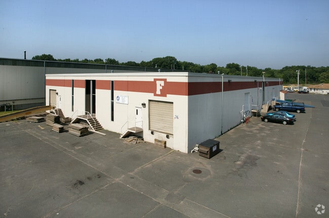
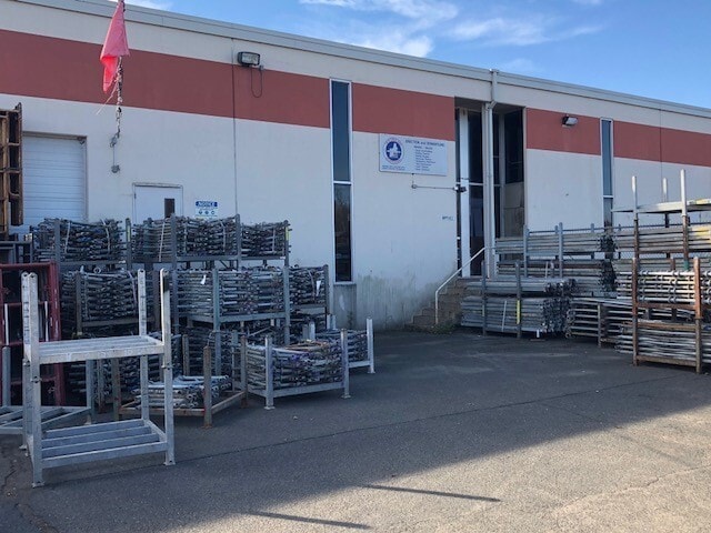
Property Record
522 Cottage Grove Rd, Bloomfield, CT 06002
Current Lease Availabilities
NEARBY LISTINGS FOR SALE OR LEASE
Property Detail
522 Cottage Grove Rd
BLOO M:37 L:279
Hartford
Industrialgeneral
Connecticut
X
278
09003C0353F
11.41 AC
2024
Bloomfield
2025
Hartford
471300
Hartford-West Hartford-East Hartford, CT
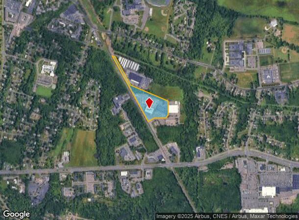
DEMOGRAPHICS near 522 Cottage Grove Rd
1 Mile
3 Mile
5 Mile
2024 Total Population
5,327
53,596
163,605
2029 Population
5,349
53,362
163,294
Pop Growth 2024-2029
+ 0.41%
(0.44%)
(0.19%)
Average Age
44
42
40
2024 Total Households
2,191
19,416
66,867
HH Growth 2024-2029
+ 0.32%
(0.55%)
(0.09%)
Median Household Inc
$69,788
$80,051
$66,146
Avg Household Size
2.30
2.40
2.30
2024 Avg HH Vehicles
2.00
2.00
1.00
Median Home Value
$210,675
$260,529
$285,687
Median Year Built
1967
1961
1958
Nearby Places
Map Layers
Map Styles
 Street
 Aerial
- Restaurants
- Banks
- Shops
- Fitness
- Groceries
PUBLIC TRANSPORTATION
COMMUTER RAIL
DRIVE
WALK
Distance
10 min
5.4 mi
DRIVE
WALK
Distance
11 min
5.4 mi
AIRPORT
Bradley International
DRIVE
WALK
Distance
Bradley International
32 min
13.2 mi
Nearby Properties
Address
Land Use
TOTAL SIZE
Lot Size
Zoning
Address
Land Use
TOTAL SIZE
Lot Size
Zoning
88.48 AC
R-10
Address
Land Use
TOTAL SIZE
Lot Size
Zoning
15,871 SF
42.80 AC
PO
Address
Land Use
TOTAL SIZE
Lot Size
Zoning
584 AC
OS
Address
Land Use
TOTAL SIZE
Lot Size
Zoning
5.56 AC
CAMP
Address
Land Use
TOTAL SIZE
Lot Size
Zoning
68.36 AC
Address
Land Use
TOTAL SIZE
Lot Size
Zoning
7.45 AC
CAMP
Address
Land Use
TOTAL SIZE
Lot Size
Zoning
227,898 SF
5.33 AC
BCD
Address
Land Use
TOTAL SIZE
Lot Size
Zoning
310,901 SF
28.75 AC
MX-2
Address
Land Use
TOTAL SIZE
Lot Size
Zoning
15.31 AC
DDZ
Address
Land Use
TOTAL SIZE
Lot Size
Zoning
433,356 SF
45.53 AC
I-2
Address
Land Use
TOTAL SIZE
Lot Size
Zoning
211,308 SF
55.90 AC
R-13
Address
Land Use
TOTAL SIZE
Lot Size
Zoning
772,060 SF
17.90 AC
DDZ
Address
Land Use
TOTAL SIZE
Lot Size
Zoning
23.10 AC
R-20
Address
Land Use
TOTAL SIZE
Lot Size
Zoning
172,026 SF
11.64 AC
MX-2
Address
Land Use
TOTAL SIZE
Lot Size
Zoning
23.07 AC
CAMP
Address
Land Use
TOTAL SIZE
Lot Size
Zoning
15.39 AC
SDD/RM
Address
Land Use
TOTAL SIZE
Lot Size
Zoning
161,576 SF
4 AC
BCD
Address
Land Use
TOTAL SIZE
Lot Size
Zoning
102,949 SF
59.10 AC
PEC
Address
Land Use
TOTAL SIZE
Lot Size
Zoning
82,938 SF
62.53 AC
I-1
Address
Land Use
TOTAL SIZE
Lot Size
Zoning
77,497 SF
14.17 AC
R-20
Address
Land Use
TOTAL SIZE
Lot Size
Zoning
135,344 SF
17.85 AC
PO
Address
Land Use
TOTAL SIZE
Lot Size
Zoning
8.17 AC
BS,R-1
Address
Land Use
TOTAL SIZE
Lot Size
Zoning
180,964 SF
32.10 AC
R-15
Address
Land Use
TOTAL SIZE
Lot Size
Zoning
6.34 AC
BS,R-1
Address
Land Use
TOTAL SIZE
Lot Size
Zoning
14.02 AC
PLR
Address
Land Use
TOTAL SIZE
Lot Size
Zoning
39.47 AC
R-15
Address
Land Use
TOTAL SIZE
Lot Size
Zoning
184,831 SF
40 AC
R-13
Address
Land Use
TOTAL SIZE
Lot Size
Zoning
31.27 AC
CAMP
Address
Land Use
TOTAL SIZE
Lot Size
Zoning
122,329 SF
4.49 AC
MX-2
Address
Land Use
TOTAL SIZE
Lot Size
Zoning
109,206 SF
4.27 AC
MX-2
The World's #1 Commercial Real Estate Marketplace
Connect with us
© 2025 CoStar Group
The information above has been obtained from sources believed reliable. While we do not doubt its accuracy we have not verified it and make no guarantee, warranty or representation about it. It is your responsibility to independently confirm its accuracy and completeness. Any projections, opinions, assumptions, or estimates used are for example only and do not represent the current or future performance of the property. The value of this transaction to you depends on tax and other factors which should be evaluated by your tax, financial, and legal advisors. You and your advisors should conduct a careful, independent investigation of the property to determine to your satisfaction the suitability of the property for your needs.